Investments
Best Delhi NCR Areas to Buy Plots for Investment in 2026

22 Nov 2025
Investments
22 Nov 2025
Content
No Blogs content found
It looks like there haven’t been any blogs yet!
Buying a plot in Delhi NCR attracts many buyers who want stable long term growth. Demand for plotted land stays steady because plots give control over future construction and usage. Delhi NCR keeps expanding through new transport links, economic corridors, ring roads, and urban development programs. These factors create consistent activity in land markets across many zones.
This article explains the best areas in Delhi NCR for plot investment. The information uses reports from the Ministry of Housing and Urban Affairs, Delhi Development Authority, Haryana Urban Development Authority, Noida Authority, Yamuna Expressway Authority, National Highways Authority of India, and research from Knight Frank, JLL India, CBRE India, and Anarock Research. These bodies provide verified updates on planning, execution, and land use progress.
The goal is to help buyers understand demand drivers, growth reasons, and future scope in each area. The approach remains simple, factual, and free from complex terms.
Plot demand comes from buyers who want control over how they build. Plotted land also follows clear regulations under state development plans. Many buyers prefer to build in phases. This makes land more flexible than finished homes.
Reports from the Ministry of Housing and Urban Affairs show stable demand for land in regions with large infrastructure projects. NHAI plans for economic corridors and expressways create new nodes for residential growth. Delhi NCR benefits from this pattern across multiple zones.
Buyers also consider cost. A plot often gives lower entry cost compared to a ready home in central zones of Delhi. The cost of land stays linked to road connectivity, future projects, and nearby job growth. This is why regions near industrial belts or upcoming expressways maintain interest from buyers and developers.
Below are the strongest regions for plot investments. Each section explains growth drivers, infrastructure, demand patterns, and future potential.
Dwarka lies near the Indira Gandhi International Airport and connects through the Delhi Metro network. Many metro stations fall in this zone which supports daily travel. The Dwarka Expressway links Dwarka with Gurugram and New Gurgaon. NHAI reports show steady progress on this expressway and service road work. This route reduces traffic load on the Delhi Gurugram corridor and supports new real estate activity.
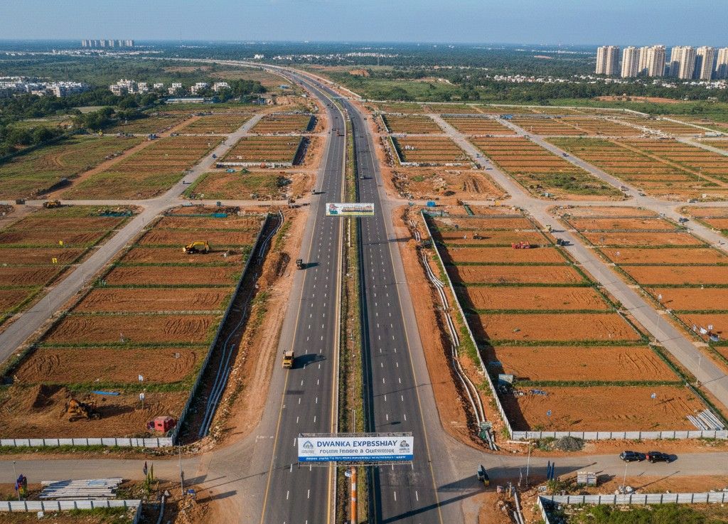
Dwarka falls near the main land pooling zones planned under the Master Plan Delhi 2041. These zones include Zone L, Zone N and Zone P.
DDA notifications show plot sizes, land use plans and circulation plans for these zones.
These zones include proposed sector roads, green belts, water bodies, and public facilities. DDA plans show reserved areas for schools, health centres, sports complexes, and commercial streets. The layout also includes drainage lines and water pipelines which follow the DDA engineering manual.
Plot buyers focus on existing plotted sectors near Dwarka. These include:
These areas include plots of many sizes. Common plot areas in these pockets range between 50 square metre, 75 square metre, 100 square metre, 150 square metre and 200 square metre. Some large plots in village pockets measure above 250 square meters.
Buyers should confirm land use status with the DDA land pooling portal and the revenue department. Many of these pockets follow mixed land use rules due to old village layouts.
Dwarka and surrounding zones influence many planned projects under public agencies and developers.
Key public projects near Dwarka include:-
These projects bring long term activity to the surrounding land pockets.
Most developer projects follow plot sizes of 60 square metre, 75 square metre, 100 square metre and 150 square metre as shown in their layout plans.
Dwarka attracts plot demand due to proximity with the airport. The airport has three terminals and ongoing expansion under the Airport Authority of India. Many new cargo and support facilities are rising near this zone which brings work for thousands of staff.
Dwarka also includes many public offices. These include offices of Delhi Police, Delhi Fire Service, Central Government Employees Housing colonies, and other public institutions. These offices create long term housing demand which supports land value in surrounding pockets.
Dwarka also connects with the Blue Line and Airport Express Line of Delhi Metro. The new Metro Phase 4 plan shows more nodes between Aerocity and Tughlakabad which pass near this belt. Metro access supports regular travel between Delhi and Gurugram and helps both end users and investors.
Government plans indicate future road links between Dwarka, the Gurugram border and Najafgarh. These include:
These works will help movement through many plotted pockets near Dwarka and will reduce travel pressure on existing roads.
Dwarka and nearby villages remain active zones for plot buyers who want long term use. Many plots fall in regularised colonies or village pockets which follow approved or notified layouts. Buyers need to check title, land use and encumbrance status before any purchase. DDA plans for land pooling and large projects like the international convention centre will shape growth in the coming years.
Najafgarh sits in the western part of Delhi and forms a major part of the Delhi Urban Extension plan under the Master Plan Delhi 2041. This belt includes rural land, authorised colonies, regularised villages and plotted pockets supported by upcoming sector layouts. Many government notifications show steady land activity in this region.
Najafgarh lies close to three major Delhi Urban Extension zones. Government documents record the following land distribution:
These zones include sector roads of thirty metre, forty five metre and sixty metre width. DDA maps show reserved land for schools, health centres, water bodies, market pockets and community spaces.
Najafgarh carries a strong cluster of plotted villages. These villages show residential layouts, local roads, mixed land use and village level infrastructure.
These villages record plots in many sizes. Common plot areas include:
Outer belts near Ghumanhera, Surhera and Kanganheri also show plots above four hundred square metre.
Najafgarh connects with several major locations which increase land activity:
These connections support steady travel and make Najafgarh a strong transition point between Delhi and Haryana.
Several public works support movement and long term usage in this region. Government reports show the following projects:
The Grey Line connects Najafgarh with Dwarka. Stations in this line include:
DMRC reports show rising ridership on this line. A metro extension from Najafgarh to Bamnoli remains under review.
Key road works include:
The Delhi government records regular work on the Najafgarh drain. The project focuses on flow improvement, deepening and cleaning. This improves surrounding land use and reduces water stagnation near Roshan Pura and parts of Nangli.
The belt connects with the KMP corridor through the Gurugram border. This link supports movement for trucks, cargo vehicles and workers. Travel time from Najafgarh to KMP through Chhawla ranges between twenty and thirty minutes.
Najafgarh sits inside the most active land pooling belt of Delhi. Many villages of Zone L and Zone N fall within or near Najafgarh. These include:
DDA records show a large share of pooling applications submitted by land owners from these villages. Pooling categories include Category one and Category two. Sector formation under pooling will include:
These factors create long term scope for plotted layouts across the belt.
Several private plotted colonies operate near Najafgarh. These include:
These layouts include local roads measuring between six meter and nine meter width. Builders usually sell plots in sizes between:
Buyers confirm local layout approval, boundaries and revenue records before purchase.
Najafgarh carries many public offices and institutions. These include:
These institutions bring steady movement and housing demand from staff and workers.
The Najafgarh belt connects to small industrial units along the Najafgarh Nangloi road. Bahadurgarh also lies nearby with many industrial sheds and factories. Workers seek housing near Surhera, Nangli and Mitraon which supports plot demand across the belt.
Key routes around Najafgarh include:
These roads carry buses, metro feeder routes and regular traffic.
Najafgarh will gain future influence from:
These works support long term plot usage and movement across the belt.
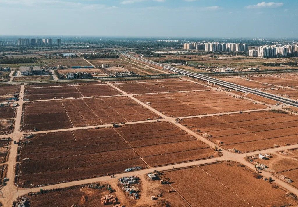
New Gurgaon lies between NH 48, Dwarka Expressway, Pataudi Road and the early stretch of the KMP corridor. This belt forms a large planned zone under the Gurugram Manesar Urban Complex plan. Haryana Urban Development Authority and Town and Country Planning Department approve many layouts in these sectors. The belt includes township projects, commercial pockets, plotted development, group housing and service infrastructure.
New Gurgaon covers a wide range of sectors. These sectors fall in the main planned cluster extending from Sector 81 to Sector 115. Government planning documents show the following listed sectors as part of the larger New Gurgaon spread:
Sector 81, Sector 82, Sector 82 A, Sector 83, Sector 84, Sector 85, Sector 86, Sector 87, Sector 88, Sector 88 A, Sector 89, Sector 90, Sector 91, Sector 92, Sector 93, Sector 94 pockets, Sector 95, Sector 95 A, Sector 95 B, Sector 99, Sector 99 A, Sector 102, Sector 103, Sector 104, Sector 105, Sector 106, Sector 107, Sector 108, Sector 109, Sector 110, Sector 110 A, Sector 111, Sector 112, Sector 113, Sector 114, Sector 115
These sectors form a continuous grid supported by thirty metre, forty five metre and sixty metre road networks shown in official plans.
Developers plan plotted areas in many sizes as per HUDA guidelines. Common plot sizes include:
Many township drawings show internal roads between nine metre and twenty four metre. Service corridors include drainage lines, water supply pipes, sewer lines, street ducts and transformer pockets.
New Gurgaon hosts many private developers with township licenses. Some of the major names include:
Their projects include plotted developments, builder floors, retail streets, group housing and mixed use blocks.
Located in Sectors 91, 92, 93 and 95 Plots range between one hundred fifty and three hundred fifty square meter Township documents show internal roads, water tanks and power stations
Located in Sectors 82 to 89 Plot sizes include one hundred to five hundred square meter Township maps show school sites, hospital sites, club sites and retail streets
Located in Sectors 81, 92, 93 and 95 Plot sizes include ninety, one hundred twenty and one hundred fifty square meter Layouts include internal roads, park pockets and community spaces
Plot sizes include one hundred twenty, one hundred fifty and one hundred eighty square meter Site plans show sewer lines, power cables, drainage lines and entry gates
Plots include one hundred fifty square metre and two hundred square metre units Township drawings include internal roads, green belts and commercial corners
These township plans follow the Haryana Development and Regulation of Urban Areas Act.
Transport remains the strongest factor for plot demand in this belt. The key routes include:
NHAI reports show around ninety percent work progress in many sections. The expressway links Manesar, New Gurgaon, Gurugram and the airport region.
NH 48 connects New Gurgaon with Delhi and Jaipur. Many sectors lie within two to six kilometres of this highway.
Pataudi Road connects New Gurgaon with old Gurugram, Farrukh Nagar and Jhajjar. Haryana PWD records show continuous work on widening and resurfacing.
KMP lies around eight to twelve kilometres from New Gurgaon sectors. This link supports industrial units and logistic movement.
A proposed metro extension from Huda City Centre to New Gurgaon remains under planning study. This line is expected to pass near Sector 101 or nearby sectors as per early plans.
The Gurugram Master Plan marks many commercial sectors around the expressway. Key notified commercial zones include:
These sectors include land for offices, retail areas, mixed use blocks, hotels and public facilities. Institutional pockets include land for:
These pockets support long term population growth in the belt.
New Gurgaon lies near many job zones. Important work zones include:
These travel times make New Gurgaon suitable for workers from multiple job corridors.
Manesar lies near this belt. Government reports show strong activity in the Manesar Industrial Model Township with:
These industries create steady housing needs for employees, which strengthens long term plot demand.
Township maps show many common facilities built inside these developments. These include:
Many developers coordinate with HUDA for road connectivity and basic services.
Several upcoming works support future activity:
These projects influence steady use of plotted land.
Plots in New Gurgaon commonly see interest from:
Plot sizes between one hundred and two hundred square meter record the highest activity due to moderate cost range.
Sohna forms the southern end of the Gurugram region and connects Gurugram with the Delhi Mumbai Industrial Corridor and KMP corridor. The belt carries planned sectors, developer townships, industrial pockets and mixed land clusters. Haryana Urban Development Authority manages many sectors in this zone. The area receives steady movement due to multiple road links between Gurugram, KMP, Palwal, Nuh and Manesar.
The Sohna belt includes planned sectors around multiple nodes. These sectors include: Sector 1, Sector 2, Sector 4, Sector 5, Sector 7, Sector 11, Sector 12, Sector 14, Sector 17, Sector 25, Sector 32, Sector 33, Sector 36, Sector 36 A, Sector 36 B
Many of these sectors fall under the Sohna Master Plan. The plan shows sector roads of thirty metre, forty five metre and sixty meter width.
Developers in Sohna offer plotted units in various sizes. Common plot sizes recorded in township layouts include:
Some private layouts also include plots of five hundred square metre and above in outer pockets.
Several developers operate townships and plotted clusters in this belt. Important names include:
Most of these developers hold licenses under the Haryana Development and Regulation of Urban Areas Act. Their township plans show internal roads, drainage lines, water systems, power lines and community spaces.
Located in Sector 32 and Sector 33. Plots include one hundred square meter, one hundred twenty square meter, one hundred fifty square meter and larger sizes. Drawings show water supply lines, sewage networks and power stations
Plots include one hundred twenty square meter and one hundred fifty square meter. Layout includes internal roads, block divisions and facility pockets
Located in Sector 14 and Sector 11 belt Plot sizes include one hundred square meter to three hundred square meter. Township documents include drainage lines, green belts and public use spaces
Plots include one hundred twenty square meter, one hundred fifty square meter and one hundred eighty square meter. Developer plans show road grids and service lines.
Located in Sector 36 and Sector 37 extension belt. Plot sizes include ninety square meter to one hundred fifty square meter.
These projects follow state rules and sector plans.
Sohna connects with major transport corridors. Important links include:
This road connects Sohna with Badshahpur and further links to Golf Course Extension Road. Widening and strengthening works appear in Haryana PWD records.
The KMP corridor lies near the southern edge of Sohna. Travel time between Sohna and KMP varies between twelve and twenty minutes depending on the sector.
DMIC passes near this belt. Industrial activity near the corridor brings steady movement of workers and support staff.
A metro link between Gurugram and Sohna appears in early planning documents. The proposal includes a route touching the Badshahpur region and moving towards Sohna.
Sohna lies near many upcoming industrial nodes. Key influences include:
Industrial workers often seek rental and ownership options near Sohna. This influences plot demand in surrounding sectors.
Commercial land pockets in Sohna include land for retail, offices and service centres. These pockets fall in Sector 2, Sector 36 and Sector 33 as per planning maps.
Many institutional sites lie in this belt. These include:
These sites appear in official layout plans and township documents.
Sohna receives demand from buyers linked with:
Buyers often choose plot sizes between one hundred square metre and two hundred square metre for self use.
Road works strongly shape land activity in Sohna. Key road projects include:
These works support steady travel between residential pockets and job zones.
Sohna borders multiple villages that also record plot transactions. Some of the active villages include:
Plot sizes in these villages vary from eighty square meter to four hundred square meter. Buyers verify revenue records through Haryana land portals.
Sohna will gain future movement from the following triggers:
These factors support long term usage of plotted land.
The Noida Greater Noida Expressway belt includes planned sectors, institutional zones, IT corridors and residential clusters. Sector 150 sits near the centre of this belt. The Noida Authority manages the sector layout, land use, road network, sports facilities, and public infrastructure. Many nearby areas contain plotted pockets in village clusters and authorised extensions. The belt attracts steady interest because of expressway travel, metro access and upcoming airport connectivity.
The expressway belt includes the following important sectors: Sector 128, Sector 129, Sector 130, Sector 131, Sector 132, Sector 133, Sector 134, Sector 135, Sector 137, Sector 142, Sector 143, Sector 143 A, Sector 143 B, Sector 144, Sector 146, Sector 147, Sector 148, Sector 150, Sector 151, Sector 152, Sector 153, Sector 155 pockets
These sectors lie between Noida Expressway, internal Noida roads and peripheral village areas.
Sector 150 holds a planned identity under the Noida Authority. The sector plan shows:
Sector 150 does not offer direct plotted schemes inside authority land. However, plotted pockets lie around the edges of Sector 150 and in nearby village zones.
Several villages near Sector 150 record active plot transactions. These include:
Nangla Charandas Gulawli Yakubpur Parthala Khanjarpur belts Bhangel extension pockets Village areas near Sector 151 Village clusters near Sector 152
These villages show mixed land use and residential layouts. Plot sizes vary across each village.
Many developers hold projects around Sector 150 and other expressway sectors. Prominent developers include:
These developers run group housing projects and mixed layouts. Their documents show internal roads, drainage lines, power stations and community facilities.
The belt includes many construction and completed projects. Key project names include:
These projects bring steady population growth which supports plotted demand in nearby villages.
Noida Authority reports list many public works in this zone. Important works include:
Sector 150 includes a planned sports zone with open grounds. Authority drawings show land reserved for sports complexes.
Sector 150 uses underground drainage and water supply networks. Noida Authority documents mention main lines connecting to sector tanks.
Power stations and transformers lie across internal blocks of Sector 150. These support residential and institutional loads.
STP units operate in Sector 123 and nearby belts. Sewage lines from Sector 150 connect to these units.
Connectivity remains the strongest reason for plot demand around Sector 150. Important routes include:
Noida Greater Noida Expressway The expressway connects Noida with Greater Noida and links further to YEIDA zones. This supports travel for workers from many companies.
Aqua Line Metro The Aqua Line connects Noida Sector 51 with Greater Noida. Stations near Sector 142 and Sector 137 lie close to plotted pockets.
Future Metro Link to Airport A metro link between Noida and the upcoming Noida International Airport appears in planning documents. This line is expected to pass through sectors near the expressway.
Road Links to Delhi Roads between Sector 150 and Kalindi Kunj support movement into Delhi. Travel time between these points depends on traffic.
The expressway belt includes major institution clusters. Key institutions include:
Institutional presence increases daily movement across this belt.
The expressway contains many office towers and IT parks. Significant sites include:
These centres bring workers who seek housing near villages and plotted pockets.
Plot buyers around Sector 150 usually come from:
Plot sizes between one hundred and one hundred fifty square metre show the highest activity due to moderate cost and flexible use.
The expressway belt will gain movement due to the following upcoming works:
These works support steady residential and plot activity.
The Yamuna Expressway Industrial Development Authority manages land surrounding the upcoming Noida International Airport at Jewar. This belt includes residential sectors, industrial clusters, logistics hubs, institutional zones and mixed use land. The region anchors many planned works and holds strong land activity due to airport construction, expressway access and YEIDA land allocation programs. The master plan shows detailed layouts for roads, drainage lines, power grids, metro corridors and public use pockets.
YEIDA manages land across a long stretch starting from Jewar towards Greater Noida. Important sectors near the airport include:
Sector 17 A, Sector 18, Sector 20, Sector 22 D, Sector 24, Sector 26 A, Sector 26 B, Sector 27, Sector 28, Sector 29, Sector 30, Sector 32, Sector 33, Sector 34
These sectors fall near Yamuna Expressway, airport road links and institutional nodes.
Yearly allotment results and auction reports show high participation. YEIDA schemes from recent years record:
Authority documents show most plots booked within short periods after allotment openings.
Sector 18 lies close to the expressway. The layout includes residential pockets, commercial nodes and institutional plots. Plots range from sixty square meters to five hundred square meters.
Sector 20 holds the highest number of allotted residential plots. Sizes include sixty square meter, ninety square meter, one hundred twenty square meter, one hundred sixty square meter and above. Sector roads include thirty meter and forty five meter routes.
Sector 22 D carries mixed residential and commercial pockets. Plot sizes range from one hundred square meter to one thousand square meter. This sector lies near upcoming metro corridors.
Sector 24 includes institutional and residential land. Plot sizes in surrounding blocks include one hundred square meter to two hundred square meter. These sectors support early residential formation around the airport region.
Noida International Airport at Jewar is under construction. Government updates note:
The airport has planned capacity for large passenger and cargo traffic. The project brings many workers, engineers and service staff who seek housing near YEIDA sectors.
Transport access remains a major factor for this region. Key links include:
This expressway connects Noida and Agra. YEIDA sectors sit directly on internal roads connected to this route.
New roads connect the airport boundary to Yamuna Expressway. Authority reports show active construction on these links.
A metro route between Greater Noida and Jewar airport appears in planning studies. This line may pass near Sector 21, Sector 22 and Sector 23 regions.
The corridor lies within reachable distance from the YEIDA belt. It supports cargo, logistics and long route travel.
YEIDA plans include service roads with thirty meter and fifty meter width across sectors.
YEIDA supports large industrial clusters in its planned areas. Key clusters include:
Includes electronics, packaging, food processing and machinery units. Land plots range between five hundred square meter and large industrial acres.
YEIDA notified an apparel manufacturing zone. Plots in this zone support garment, stitching and textile units.
This park supports medical equipment manufacturing. Authority reports show land allocation to several companies.
A Film City proposal lies in Sector 21 or nearby pockets. The plan includes media units, production offices and support facilities.
YEIDA supports warehousing units near Sector 28 and Sector 29.These units benefit from direct expressway access.
Many institutional land parcels lie in YEIDA sectors. These include:
The master plan marks these sites in multiple sectors.
Many nearby villages also record plot transactions. Active villages include:
Village plot sizes range between eighty square meter and five hundred square meter.Buyers check revenue entries through Uttar Pradesh land records.
Plot buyers in YEIDA region usually consist of:
Plot sizes between one hundred square meter and two hundred fifty square meter show the highest interest.
YEIDA region will grow due to the following triggers:
These triggers increase movement across the belt and create stable plot demand.
The Faridabad Sectors 75 to 89 belt lies inside the planned boundary of the Faridabad Master Plan. Haryana Town and Country Planning Department manages sector layouts and land use plans for this region. The belt contains plotted layouts, group housing pockets, commercial nodes, industrial influence zones, institutional blocks and mixed land pockets. Many private developers operate plotted clusters under licensed colony rules.
The belt covers a continuous grid of sectors that fall between the internal Faridabad roads, the bypass stretch, and the Ballabhgarh link. The main sectors include:
Sector 75, Sector 76, Sector 77, Sector 78, Sector 79, Sector 80, Sector 81, Sector 82, Sector 83, Sector 84, Sector 85, Sector 86, Sector 87, Sector 88, Sector 89
Sector roads in these areas include thirty meter, forty five meter and sixty meter widths as shown in state maps.
Several developers hold township licenses or plotted colony approvals in this belt. Key developers include:
These developers submit layout plans showing internal roads, drainage lines, sewer networks, water pipelines, transformer sites and park land.
Located across Sectors 75 to 88. Plots include one hundred square meter to three hundred square meter. Township plans show internal roads, community land and utility pockets
Located in Sector 89. Plots include one hundred twenty square meter and one hundred fifty square meter. Developer plans show internal road networks and facility areas.
Plots include one hundred square meter to two hundred square meter. Layout plans show water pipelines and sewage lines.
Located near Sector 87. Surrounding plotted pockets include one hundred square meter to one hundred fifty square meter plots.
Located in Sector 86. Nearby plotted pockets follow sizes between eighty square meter and two hundred square meter
These projects support population growth across the belt which increases demand for plotted land near these sectors.
The Faridabad Master Plan marks multiple institutional sites across Sectors 75 to 89. These include:
These institutional spaces appear in multiple sectors including 77, 81, 85, 87 and 89.
Faridabad carries one of the biggest industrial clusters in Haryana. Industrial areas near this belt include:
Industries include auto parts, machinery, fabrication, packaging, garment units, rubber units and electrical products. Workers from these industries often choose housing near Sectors 75 to 89 which increases demand for residential plots.
Connectivity helps the belt record steady interest. Key routes include:
This highway links Faridabad with Delhi and Palwal. Sectors 75 to 89 lie within short drive range of this route.
This road links Faridabad with Gurugram. Travel between Sectors 81 to 89 and Gurugram depends on traffic flow.
Metro line connects Faridabad with Delhi. Metro stations lie near Neelam Ajronda and Bata Chowk, which support residents from nearby sectors.
The bypass connects Ballabhgarh with industrial and residential pockets. Many sectors between 75 and 89 lie near this route.
Maps show proposed sector roads connecting Sector 75 to Sector 89, including direct roads to Tigaon Road and bypass stretches.
Village belts near these sectors include:
These villages include mixed use land and plotted areas. Plot sizes vary from eighty square meter to four hundred square meter.
Commercial pockets lie in Sector 79, Sector 81, Sector 85 and Sector 88. These pockets include:
Commercial pockets attract residents which supports residential plot demand.
State departments run multiple works in this region. Key works include:
Sewer lines connect many sectors to main STP units. STPs in nearby sectors treat sewage from these zones.
Haryana PWD and Faridabad municipal body manage pipelines. Layout maps show water supply connections for each sector.
Electric substations lie in Sector 77, Sector 81, Sector 85 and Sector 89.Transformers and underground cables appear in many township layouts.
Road widening and strengthening appear in sectors like 79, 85 and 88. PWD reports note resurfacing in many pockets.
Plot demand comes from:
Plot sizes between one hundred square meter and two hundred square meter record the most activity.
This belt will gain future movement due to:
These factors support long term usage of plotted land.
Buying a plot involves detailed checks. These checks prevent disputes and financial loss.
Buyers must verify ownership through the revenue department. Mutation records, registry documents, and khasra numbers confirm real ownership.
Buyers should confirm whether the land falls under residential, agricultural, or commercial use. Development authorities provide this information.
DDA, HUDA, Noida Authority, Greater Noida Authority, and YEIDA provide layout permissions. Buyers should request these documents.
Plots near approved sector roads hold stronger demand. Government plans and NHAI reports confirm future road projects.
Approved sectors usually include drainage, sewer lines, and water supply. This reduces future construction cost.
Job hubs create long term housing demand. Reports from CBRE, Knight Frank, and JLL show job patterns in the NCR region.
Metro lines, expressways, and industrial corridors create a strong value impact. Government planning documents confirm these projects.
Delhi NCR continues to grow through planned expansion, new highways, metro lines, and industrial corridors. Plots remain in demand because they offer control, flexibility, and long term value. Regions like Dwarka, New Gurgaon, Sohna, Manesar, Noida Expressway, YEIDA, Faridabad, and Raj Nagar Extension show clear signs of long term growth based on verified government plans. Buyers should study land use rules, confirm ownership, and match their budget with future growth potential. Government data and research reports help buyers make stable decisions without depending on uncertain views.
Contact Us
Fill out this form
& we'll get back
to you
Recommended for you


