Investments
Delhi Metro Phase V(B): 7 New Corridors, 65 Stations, Cost, Timeline and Route Details

08 Jun 2026
Investments
08 Jun 2026
Content
No Blogs content found
It looks like there haven’t been any blogs yet!
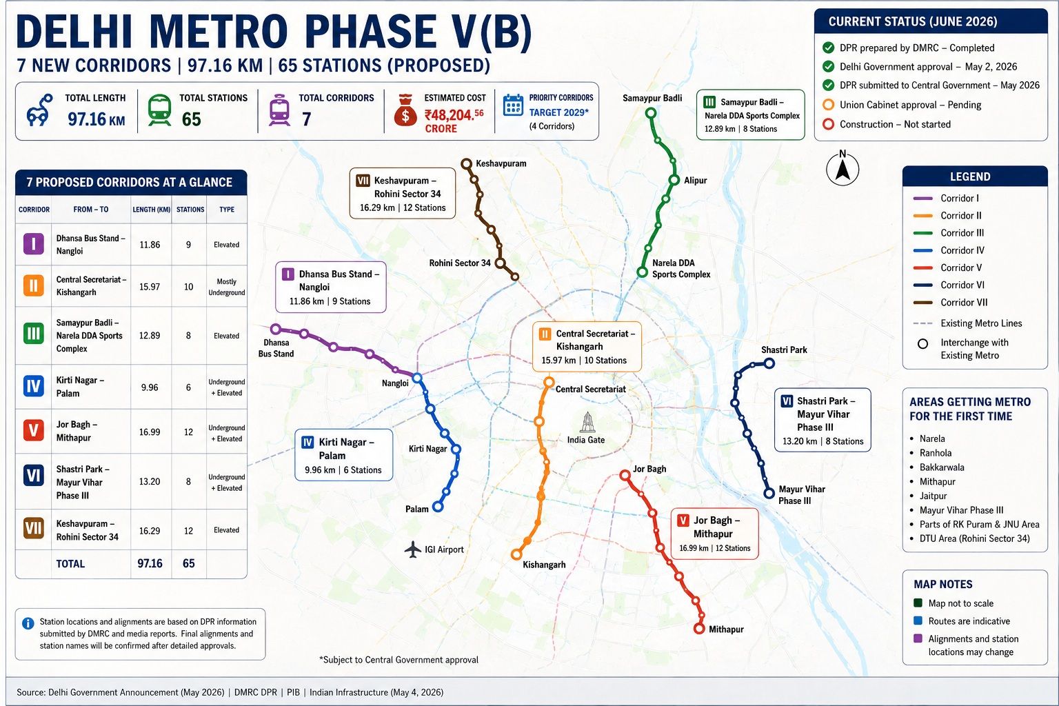
Delhi Metro Phase V(B) is the next planned expansion of the Delhi Metro network, covering 97.16 km across seven new corridors with 65 stations. The Delhi government approved the project on May 2, 2026. The Detailed Project Report (DPR) has been submitted to the Central Government and is awaiting Union Cabinet clearance before construction can begin.
This guide covers the project status, all seven corridors, the full cost breakdown, timeline, areas that will get metro for the first time, and the expected impact on Delhi's real estate market.
Delhi Metro Phase V(B) is a proposed 97.16 km metro expansion comprising seven corridors and 65 stations across Delhi. The project has received Delhi Government approval and is awaiting Union Cabinet approval as of June 2026. It targets areas that have historically lacked metro connectivity — including Narela, outer-west Delhi, south Delhi's interior around RK Puram and JNU, east Delhi's Gandhi Nagar zone, and Mayur Vihar Phase III.
The estimated project cost is ₹48,204.56 crore, making it one of Delhi Metro's largest expansion proposals after Phase IV. Funding will follow Delhi Metro's standard three-way model: Central Government, Delhi Government, and international funding agencies.
| Stage | Status |
|---|---|
| DPR Preparation by DMRC | Completed |
| Delhi Government Approval | Completed — May 2, 2026 |
| DPR Submission to Central Government | Completed — May 2026 |
| Central Government Review | In Progress |
| Union Cabinet Approval | Pending |
| Financial Sanction | Not Yet Initiated |
| Construction | Not Started |
What this means: The project has cleared the Delhi Government stage and is now under Central Government review. Union Cabinet approval is the next mandatory step. No construction can begin, and no tenders can be floated , until Cabinet clears the project and both governments issue financial sanctions.
| Event | Date | Status |
|---|---|---|
| DPR Prepared by DMRC | Early 2026 | Completed |
| Delhi Government Approval | May 2, 2026 | Confirmed |
| Announcement by CM Rekha Gupta | May 3, 2026 (DMRC Foundation Day) | Confirmed |
| DPR Submitted to Central Government | May 2026 | Confirmed |
| Union Cabinet Approval | Awaited | Pending |
| Construction Start | Not Announced | Awaited |
Current status: The Delhi government has approved Phase V(B) and the DPR is with the Centre. Union Cabinet clearance is the next critical milestone. Four corridors have been designated priority corridors, targeting completion by 2029, subject to central approval.
| Parameter | Details |
|---|---|
| Total Route Length | 97.16 km |
| Total Stations | 65 |
| Total Corridors | 7 |
| Estimated Total Cost | Rs 48,204.56 Crore |
| Implementing Agency | Delhi Metro Rail Corporation (DMRC) |
| Delhi Government Approval | May 2, 2026 |
| DPR Status | Submitted to the Central Government; Union Cabinet Approval Pending |
| Priority Corridors Target | 2029 (4 Corridors) |
Source: Delhi Government announcement, May 2026; Indian Infrastructure, May 4, 2026; PIB
| Parameter | Existing Network | Phase V(B) Addition |
|---|---|---|
| Route Length | 374+ km | 97.16 km |
| Total Stations | 270+ | 65 New Stations |
| Corridors | Multiple Existing Lines | 7 New Corridors |
| Geographic Coverage | Core Delhi and Select Peripheral Areas | North, North West, West, Outer West, South Interior, South East, and East Delhi |
| Approval Status | Operational | Pending Union Cabinet Clearance |
Once operational, Phase V(B) would expand Delhi Metro's route length by approximately 26 percent and add 65 stations to a network that currently serves over 270 stations.
Phase IV of Delhi Metro covers 111 km with 83 stations across six corridors. As of late 2025, approximately 80 percent of civil construction on the three priority corridors was complete, with target completion set for December 2026. Phase IV focuses on south Delhi, west Delhi, and Haryana connectivity. Phase V(B) goes further — into areas that Phase IV does not reach.
DMRC's current network: According to DMRC's operational data, Delhi Metro currently operates over 374 km with more than 270 stations. In 2025, the network recorded 235.8 crore passenger journeys — an average of 64.6 lakh per day, with a single-day peak of 81.87 lakh on August 8, 2025. Despite this scale, large residential areas remain outside the metro grid. Phase V(B) is designed to bring those areas in.
| Corridor | From | To | Length (km) | Stations | Type |
|---|---|---|---|---|---|
| I | Dhansa Bus Stand | Nangloi | 11.86 | 9 | Fully Elevated |
| II | Central Secretariat | Kishangarh | 15.97 | 10 | Mostly Underground |
| III | Samaypur Badli | Narela DDA Sports Complex | 12.89 | 8 | Fully Elevated |
| IV | Kirti Nagar | Palam | 9.96 | 6 | Underground and Elevated |
| V | Jor Bagh | Mithapur | 16.99 | 12 | Underground and Elevated |
| VI | Shastri Park | Mayur Vihar Phase III | 13.20 | 8 | Underground and Elevated |
| VII | Keshavpuram | Rohini Sector 34 | 16.29 | 12 | Fully Elevated |
| Total | 97.16 | 65 |
Source: Indian Infrastructure / DMRC DPR as reported by Delhi Government, May 2026
Check this:- Delhi Metro Phase 5: Three Game Changing Corridors and Investment Opportunities
One of Phase V(B)'s most significant aspects is how many populated areas will receive metro access for the first time. These localities currently depend entirely on road-based transport for their daily commute needs.
| Area | Proposed Corridor |
|---|---|
| Narela | Corridor III |
| Mithapur | Corridor V |
| Jaitpur | Corridor V |
| Madanpur Khadar | Corridor V |
| Bakkarwala | Corridor I |
| Ranhola | Corridor I |
| Mayur Vihar Phase III | Corridor VI |
| Gandhi Nagar Market Area | Corridor VI |
| RK Puram | Corridor II |
| JNU Area | Corridor II |
| Delhi Technological University (DTU) Area | Corridor VII |
| Rohini Interior Sectors (16, 29) | Corridor VII |
Note: Final station locations are subject to DMRC's official confirmation after Union Cabinet approval. The localities above are indicative, based on corridor alignment information available as of June 2026.
DMRC has confirmed 65 stations across the seven corridors. Official station-by-station names have not been publicly released as of June 2026, since the project is awaiting Union Cabinet approval. The station counts by corridor are confirmed as follows:
Based on corridor alignments reported in available DPR documents and media coverage, the broad localities expected to be served include: Ranhola, Bakkarwala (Corridor I); New Moti Bagh, RK Puram, JNU, Kishangarh (Corridor II); Siraspur, Khera Kalan, Holambi Kalan, Alipur, Narela (Corridor III); west Delhi localities between Kirti Nagar and Palam (Corridor IV); Lodhi Colony, Lajpat Nagar, Okhla, Jasola, Madanpur Khadar, Jaitpur, Mithapur (Corridor V); Geeta Colony, Gandhi Nagar, Patparganj, Mayur Vihar Phase III (Corridor VI); Pitampura, multiple Rohini sectors, DTU, Rohini Sector 34 (Corridor VII).
Important note: Final station names, exact locations, and detailed alignments will be confirmed only after Union Cabinet approval and DMRC's formal publication of the approved DPR. The locality names above are indicative based on currently available information. This page will be updated when DMRC officially publishes the station names.
An official route map for Phase V(B) has not been published by DMRC as of June 2026, since the project is awaiting Union Cabinet approval. Based on the DPR submitted by DMRC and the corridor alignments announced by CM Rekha Gupta, the broad geographic spread is as follows:
North Delhi: Corridor III runs from Samaypur Badli northward to Narela DDA Sports Complex.
North-West Delhi: Corridor VII runs from Keshavpuram through Pitampura and multiple Rohini sectors to Rohini Sector 34.
West Delhi: Corridor I connects Dhansa Bus Stand through outer-west localities to Nangloi. Corridor IV connects Kirti Nagar to Palam.
South Delhi: Corridor II goes underground from Central Secretariat through Moti Bagh, RK Puram, and JNU to Kishangarh.
South and South-East Delhi: Corridor V runs from Jor Bagh through Lajpat Nagar, Okhla, Jasola, and Madanpur Khadar to Mithapur.
East Delhi: Corridor VI links Shastri Park to Mayur Vihar Phase III via Geeta Colony, Gandhi Nagar, and Patparganj.
When DMRC releases an official route map post-Cabinet approval, this section will be updated with the published alignment.
Understanding why these corridors were chosen explains both their strategic value and their long-term significance for Delhi's urban development.
Population growth in unserved areas
Delhi's population continues to grow fastest at its periphery — Narela, Rohini's outer sectors, Mayur Vihar Phase III, and outer-west localities like Bakkarwala and Ranhola. These are among Delhi's most densely populated zones that still fall entirely outside the metro network. Phase V(B) corridors were selected specifically to close these gaps.
DDA housing clusters
The Delhi Development Authority has built large planned residential colonies in Narela (Corridor III), Rohini (Corridor VII), and Dwarka-adjacent zones (Corridor IV). These colonies house hundreds of thousands of residents who currently depend entirely on road-based transport. DMRC's selection of these corridors aligns with the Central Government's and Delhi Government's stated policy of extending mass transit to planned housing areas.
Metro coverage gaps identified in network analysis
Delhi Metro's existing network has well-documented coverage gaps: south Delhi's interior (RK Puram, JNU), east Delhi beyond Patparganj, and the belt from Shastri Park to Mayur Vihar Phase III. Corridors II, V, and VI directly address these gaps.
Industrial and commercial centres
Gandhi Nagar wholesale market (Corridor VI) is one of the largest wholesale cloth markets in Asia and generates enormous daily footfall. NSIC Okhla industrial area (Corridor V) is a major employment hub. These corridors extend metro access to significant employment generators.
University and institutional campuses
JNU (Corridor II) and Delhi Technological University (Corridor VII) are large campuses with thousands of students and faculty who depend on public transport. Both have historically been outside the metro grid, and connecting them was a stated policy priority.
Integration with Phase IV network
Several Phase V(B) corridors are designed to complement Phase IV's under-construction network. Corridor III (Narela) integrates with the Phase IV Rithala-Kundli Red Line extension at Narela DDA Sports Complex. Corridor V connects with the Golden Line at Madanpur Khadar. These integration points multiply the utility of both phases.
Also Read this:- Shastri Park to Mayur Vihar Phase 3 Metro Route Map, Cost, Timeline and Benefits
Route and alignment
Fully elevated. Runs 11.86 km from Dhansa Bus Stand in outer-west Delhi to Nangloi in west Delhi. Based on available DPR reports, the corridor is expected to serve localities including Ranhola, Bakkarwala, and areas along the Najafgarh extension belt. Final station locations will be confirmed after Cabinet approval.
Interchange stations
Interchange with the Grey Line at Dhansa Bus Stand and the Green Line at Nangloi, effectively connecting two currently separate lines in the west Delhi metro network.
Areas served
Outer-west localities including Dhansa, Bakkarwala, and Ranhola — areas with no current metro access that rely entirely on road transport.
Strategic importance
Creates a new east-west link in outer west Delhi, reducing dependence on congested Najafgarh Road and connecting two currently separate metro lines.
Route and alignment
Mostly underground — 13.73 km underground, the rest elevated. Runs from Central Secretariat southward through south Delhi's interior. Based on available DPR-aligned media reports, the corridor is expected to serve areas including New Moti Bagh GPRA colonies, RK Puram sectors, Jawaharlal Nehru University (JNU), and the PM Museum area, ending at Kishangarh. Final station names and exact alignments remain subject to official confirmation after Cabinet approval.
Interchange stations
Four interchange points: Central Secretariat (Yellow, Violet, and Magenta lines), Moti Bagh (Pink Line), RK Puram (Magenta Line), and Kishangarh (Golden Line).
Areas served
New Moti Bagh (large government residential colony), RK Puram (government employee housing), JNU campus, PM Museum area, and Kishangarh — all lacking direct metro access today.
Strategic importance
Four interchange connections make this one of the most network-critical corridors in Phase V(B), providing underground metro access to south Delhi's interior for the first time.
Route and alignment
Fully elevated. Extends the existing Yellow Line northward from Samaypur Badli to Narela DDA Sports Complex. Based on available DPR reports, the alignment is expected to pass through areas such as Siraspur, Khera Kalan, Holambi Kalan, Alipur, and Shahpur Garhi. Final station positions are subject to official DMRC confirmation after Cabinet clearance.
Interchange stations
Interchange at Siraspur (Yellow Line) and at Narela DDA Sports Complex with the Phase IV Red Line extension (Rithala-Kundli corridor, Cabinet-approved in December 2024 per PIB).
Areas served
Narela DDA residential sectors, DSIIDC Narela industrial area, Holambi Kalan, Alipur, and Khera Kalan — all in outer north Delhi.
Strategic importance
Narela is one of DDA's largest planned housing developments with a large residential population dependent on road transport. This corridor provides Narela's first direct Yellow Line connection to central Delhi. Combined with the Phase IV Red Line extension from Rithala, Narela will eventually have two separate metro connections.
Route and alignment
Runs 9.96 km with 8.39 km underground and 1.57 km elevated. Six stations — five underground and one elevated. Connects west Delhi's Kirti Nagar to Palam, covering localities that currently require multiple transfers to travel between west and south-west Delhi.
Interchange stations
Interchange at Kirti Nagar (existing metro network) and connectivity toward Palam and the south-west Delhi metro network.
Areas served
West Delhi residential areas between Kirti Nagar and Palam. Final station names for intermediate stops will be confirmed post-Cabinet approval.
Strategic importance
Connects two well-established parts of Delhi without a direct metro link today. Estimated at approximately Rs 6,200 crore. Palam's proximity to IGI Airport's domestic terminal also gives this corridor strategic importance for western Delhi commuters.
Route and alignment
The longest corridor in Phase V(B) at 16.99 km. Mixed construction — underground and elevated sections — with twelve stations including seven underground. Based on available DPR-aligned information, the corridor is expected to serve areas such as Lodhi Colony, Lajpat Nagar, the NSIC Okhla zone, Jasola Apollo, Madanpur Khadar, Jaitpur, and Mithapur. Final station names and exact alignment are subject to DMRC's official confirmation after Cabinet approval.
Interchange stations
Five interchange points — the most of any corridor in Phase V(B): Jor Bagh (Yellow Line), Lajpat Nagar (Violet and Pink lines), NSIC Okhla (Magenta Line), Jasola Apollo (Violet Line), and Madanpur Khadar (Golden Line extension).
Areas served
Lodhi Colony, Lajpat Nagar, Okhla industrial area, Jasola, Madanpur Khadar, Jaitpur, and Mithapur. Areas like Madanpur Khadar and Jaitpur in outer south-east Delhi have grown rapidly in population but have limited metro access today.
Strategic importance
Five interchanges make this the most connectivity-rich corridor in Phase V(B), creating a continuous north-south spine through south and south-east Delhi.
Route and alignment
13.20 km with approximately 9 km underground. Connects Shastri Park in north-east Delhi to Mayur Vihar Phase III in east Delhi. Based on available DPR reports, the corridor is expected to serve areas including Geeta Colony, Gandhi Nagar market, Patparganj, and Mayur Vihar Phase III. Final alignments and station names will be confirmed after formal approvals.
Interchange stations
Shastri Park (Red Line), Nirman Vihar (Blue Line), and Trilokpuri (Pink Line).
Areas served
Gandhi Nagar market (one of Asia's largest wholesale cloth markets), Geeta Colony, Patparganj, and Mayur Vihar Phase III. Mayur Vihar Phase III has no metro station of its own despite a large residential population; the nearest stations are on the Blue Line at Mayur Vihar Phase I and New Ashok Nagar.
Strategic importance
Addresses one of east Delhi's most persistent connectivity gaps, with three interchange connections and direct access to Gandhi Nagar market — which attracts thousands of traders and buyers daily but is currently unreachable by metro.
Route and alignment
Fully elevated with 12 stations over 16.29 km. Runs from Keshavpuram northward to Rohini Sector 34. Based on available DPR-aligned reports, the corridor is expected to pass through areas including West Shalimar Bagh, Pitampura, Rohini Sectors 16 and 29, and Delhi Technological University (DTU). Final station positions will be confirmed post-Cabinet approval.
Interchange stations
Keshavpuram (Red Line), North Pitampura (Pink Line), and Rohini Sector 34 (Red Line).
Areas served
Multiple Rohini sectors, Pitampura, West Shalimar Bagh, and Delhi Technological University campus. Rohini is one of Delhi's largest planned residential areas; the existing Red Line covers only the eastern edge.
Strategic importance
Estimated at Rs 4,869.56 crore. Creates a loop within north-west Delhi — connecting the Red Line at two different points (Keshavpuram and Rohini Sector 34) via a route that covers areas not currently on any metro line.
| Parameter | Value |
|---|---|
| Total Estimated Project Cost | Rs 48,204.56 Crore |
| Cost — Corridors I to VI | Rs 43,335 Crore (Approx.) |
| Cost — Corridor VII Alone | Rs 4,869.56 Crore |
| Total Route Length | 97.16 km |
| Approximate Cost Per Kilometre | Rs 496 Crore |
| Total Stations | 65 |
| Funding Model | Central Government + Delhi Government + International Funding Agencies |
Source: Delhi Government, May 2026; Indian Infrastructure, May 4, 2026
Funding structure
Delhi Metro projects are funded jointly by the Central Government, the Delhi Government, and international funding agencies. The Japan International Cooperation Agency (JICA) has historically provided loans for Delhi Metro phases — a model confirmed in PIB releases for Phase IV and Phase V(A). Phase V(A), approved in December 2025, follows this same three-way funding model. The exact funding split for Phase V(B) has not been officially disclosed as of June 2026, since Union Cabinet clearance is still pending.
Cost in context
Phase V(A) costs Rs 12,015 crore for 16 km — Rs 751 crore per km. Phase IV's Rithala-Kundli corridor, approved in December 2024 per PIB, costs Rs 6,230 crore for 26.46 km — Rs 235 crore per km (all elevated). Phase V(B)'s Rs 496 crore per km average reflects the high proportion of underground construction across Corridors II, IV, V, and VI, which is significantly more expensive than elevated construction.
| Stage | Expected Timeline |
|---|---|
| DPR Preparation by DMRC | Completed (Early 2026) |
| Delhi Government Approval | May 2, 2026 (Confirmed) |
| DPR Submitted to Central Government | May 2026 (Confirmed) |
| Union Cabinet Approval | Awaited — No Timeline Announced |
| Financial Sanction (Both Governments) | After Union Cabinet Approval |
| Construction Start | After Financial Sanction |
| Priority Corridors (4 Corridors) | Target Completion by 2029 |
| Remaining Corridors | Timeline to Be Announced After Union Cabinet Approval |
Note on timeline realism
Delhi Metro approval-to-construction timelines can be lengthy. The Rithala-Kundli corridor (Phase IV) was Cabinet-approved in December 2024, and construction tender notices were still pending in early 2026. The Lajpat Nagar-Saket and Inderlok-Indraprastha corridors were Cabinet-approved in March 2024. Buyers and investors tracking Phase V(B) should account for a realistic gap between approval and on-ground construction, typically 12 to 24 months after Cabinet clearance.
North Delhi (Corridor III)
Corridor III (Samaypur Badli to Narela) gives Narela its first Yellow Line connection. Narela DDA Sports Complex will become an interchange with the Phase IV Red Line extension. Together, these two connections will transform Narela's daily commuting options, which currently depend almost entirely on road transport.
North-West Delhi (Corridor VII)
Corridor VII (Keshavpuram to Rohini Sector 34) expands metro access across Rohini and Pitampura. Rohini is home to hundreds of thousands of residents across dozens of DDA sectors. The current Red Line covers only the eastern fringe. DTU campus, with thousands of students, will finally have metro access.
South Delhi (Corridors II and V)
Corridor II goes underground through RK Puram and JNU to Kishangarh, creating access to south Delhi's interior. Corridor V runs 17 km from Jor Bagh through Lajpat Nagar, Okhla, Jasola, and Madanpur Khadar to Mithapur. Together, these two corridors add significant metro depth to south Delhi.
West and Outer-West Delhi (Corridors I and IV)
Corridor I (Dhansa Bus Stand to Nangloi) connects outer-west localities that have no metro access today. Corridor IV (Kirti Nagar to Palam) improves west-to-south-west connectivity.
East Delhi (Corridor VI)
Corridor VI (Shastri Park to Mayur Vihar Phase III) covers Gandhi Nagar, Geeta Colony, Patparganj, and Mayur Vihar Phase III — east Delhi zones with high residential and commercial density that have had limited metro access for years.
| Area | Corridor | Current Connectivity | Expected Gain |
|---|---|---|---|
| Narela | Corridor III | No Metro Access | Connectivity to Yellow Line and Red Line Interchange |
| Rohini Sectors 16, 29, 34 | Corridor VII | Red Line Access Only on the Eastern Edge | New Elevated Metro Link Through Interior Rohini |
| Delhi Technological University (DTU) | Corridor VII | No Metro Access | First Dedicated Metro Station for the Campus Area |
| Mithapur / Jaitpur | Corridor V | No Metro Access | Direct Access Through a 12-Station South East Delhi Corridor |
| Bakkarwala / Ranhola | Corridor I | No Metro Access | First Metro Connectivity for Outer West Delhi Areas |
| Mayur Vihar Phase III | Corridor VI | Blue Line Located More Than 2 km Away | Dedicated Metro Station Within Phase III |
| Gandhi Nagar Market | Corridor VI | No Metro Access | Direct Metro Connectivity to the Market Area |
| RK Puram / JNU | Corridor II | No Direct Metro Access | Underground Connectivity Through a Four-Interchange Corridor |
| Madanpur Khadar | Corridor V | No Metro Access | Interchange Connectivity Through the Golden Line Extension |
| Palam | Corridor IV | Limited Existing Metro Access | New Direct Metro Link Across West Delhi |
| Parameter | Phase IV | Phase V(B) |
|---|---|---|
| Total Length | 111 km | 97.16 km |
| Total Stations | 83 | 65 |
| Number of Corridors | 6 | 7 |
| Approximate Total Cost | Rs 60,000+ Crore | Rs 48,204.56 Crore |
| Union Cabinet Approval | Yes (2019–2024, in Stages) | Pending (As of June 2026) |
| Delhi Government Approval | Yes | Yes (May 2, 2026) |
| Construction Status | Ongoing | Not Started |
| Primary Geography | South Delhi, West Delhi, Haryana Border | North Delhi, North West Delhi, Outer West Delhi, South Interior Delhi, and East Delhi |
| Maximum Interchanges on a Single Corridor | Multiple | 5 (Jor Bagh to Mithapur, Corridor V) |
| Priority Corridor Target | December 2026 | 2029 (4 Corridors, Subject to Union Cabinet Approval) |
Metro expansion consistently improves property demand in areas that gain connectivity. Delhi Metro's history provides clear evidence of this pattern, and Phase V(B) may follow a similar trajectory — subject to the project receiving Union Cabinet approval and progressing through construction.
Properties within 1 km of metro stations are typically priced 10 to 30 percent higher than comparable properties farther away (Source: realtynmore.com, April 2026). Near Delhi Metro stations, residential land values within 500 metres have risen 11.3 percent on average and commercial values 18.1 percent on average, with peripheral zones showing larger percentage gains because they start from a lower base.
The Blue Line, which opened in 2005 and connected Dwarka to Noida, contributed to a significant rise in property values in Noida (Source: 99acres.com). Dwarka went from a peripheral DDA area to one of Delhi's most established residential sub-cities — a useful comparable for areas like Narela and Mithapur today.
| Location | Current Price | Metro Status | Potential Demand Driver |
|---|---|---|---|
| Narela | ₹5,550/sq ft | No Metro | Yellow Line Access and First Metro Connectivity |
| Mithapur | ₹1,400/sq ft | No Metro | First Metro Connectivity from a Very Low Price Base |
| Rohini Sector 34 | ₹7,681/sq ft | Limited Access (Red Line More Than 3 km Away) | Improved Interior Sector Connectivity Through Corridor VII |
| Mayur Vihar Phase III | ₹9,000/sq ft | Limited Access (Blue Line More Than 2 km Away) | Dedicated Metro Station Addresses a Long Standing Connectivity Gap |
| Palam | ₹7,100–8,500/sq ft | Existing Limited Access | Better Direct Connectivity Across West Delhi |
| Gandhi Nagar | ₹9,000/sq ft Zone | No Metro | Direct Metro Access to a Major Commercial Market |
| Bakkarwala / Ranhola | Below Delhi Average | No Metro | First Ever Metro Connectivity in the Outer West Delhi Belt |
Note: Property prices are current market asking rates from 99acres.com and Squareyards (data as of late 2025/early 2026). "Potential demand driver" reflects connectivity change only — not a price guarantee or investment recommendation. All projections are subject to project receiving Union Cabinet approval and construction progressing as planned.
Narela averages around Rs 5,550 per sq ft — well below the Delhi average for connected areas. The locality has already seen 11 percent appreciation in one year (99acres, 2025) and 37 percent over five years, without metro connectivity. Phase V(B) Corridor III would be its first direct metro link to central Delhi via the Yellow Line. Narela may witness stronger demand if the corridor receives Cabinet approval and construction progresses as planned.
Mithapur is priced at Rs 1,400 per sq ft (99acres, May 2026), reflecting its current isolation. Corridor V connects it via a 12-station, five-interchange corridor. Mithapur may see increased interest if project timelines materialise, following the pattern seen in other first-access peripheral areas.
Mayur Vihar Phase III is priced at Rs 9,000 per sq ft (99acres, May 2026) despite no dedicated metro station. Corridor VI would close the connectivity gap that has held prices below those of Mayur Vihar Phase I and II — suggesting room for further demand strengthening if the project proceeds.
Rohini Sector 34 is priced at around Rs 7,681 per sq ft (Squareyards, December 2025), with the Red Line more than 3 km away. Corridor VII's fully elevated alignment through multiple Rohini sectors may reduce effective commute times and narrow the connectivity discount currently priced in.
Metro access generally improves rental yields by expanding the pool of potential tenants. Areas served by Corridors II (RK Puram, JNU) and VII (DTU, Rohini) are particularly likely to see increased rental demand from students and young professionals if the project is completed.
Phase V(B) has Delhi government approval but is awaiting Union Cabinet clearance as of June 2026. Construction has not started. Real estate appreciation linked to metro announcements builds gradually and typically peaks closer to inauguration, not at the proposal stage. Buyers should evaluate properties on fundamental merit — price, title, RERA registration, infrastructure, and livability — and conduct independent due diligence before any investment decision.
Union Cabinet Approval
The DPR is with the Central Government. Without Cabinet approval, no financial sanction is possible and construction cannot begin. There is no confirmed timeline for this clearance.
Funding Confirmation
At Rs 48,204 crore, Phase V(B) requires a large joint commitment from the Central and Delhi governments. Funding ratios and international loan arrangements need to be structured and agreed upon after Cabinet clearance.
Land Acquisition
Elevated corridors (I, III, VII) require land for stations, depots, and entry-exit points. Land acquisition in Delhi is complex and can delay projects even after approval. Underground sections avoid most surface acquisition but require clearance of utilities and access points.
Utility Shifting
Tunnelling under built-up areas in Corridors II, V, and VI passes through zones with dense utility networks — water pipelines, sewage lines, power cables, and telecom ducts. Shifting these utilities before tunnelling is time-consuming and a major cost and schedule driver.
Construction in Congested Areas
Corridors II, V, and VI pass through some of Delhi's most congested areas. Underground construction in such zones causes significant surface disruption during the construction period.
Simultaneous Seven-Corridor Execution
Managing seven corridors simultaneously — some underground, some elevated, across different zones of Delhi — is a complex coordination challenge for DMRC in terms of contractor mobilisation, procurement, and project management.
Delhi Metro Phase V(B) is the most geographically comprehensive metro expansion Delhi has proposed since Phase IV. At 97.16 km, 65 stations, and seven corridors covering north, north-west, west, outer-west, south, south-east, and east Delhi, it addresses metro gaps that have remained for years.
The Delhi government approved the project on May 2, 2026, and the DPR has been submitted to the Central Government. Union Cabinet approval is the next critical step. Four corridors are targeted for completion by 2029 after that clearance comes through.
For commuters, the corridors that matter most are Corridor III (Narela's first metro link), Corridor VII (Rohini interior and DTU connected), Corridor V (south and south-east Delhi spine with five interchanges), and Corridor VI (Gandhi Nagar and Mayur Vihar Phase III served). Each corridor reaches a large residential or commercial population that currently has no metro access.
For real estate buyers and investors, Phase V(B) puts areas like Narela (Rs 5,550 per sq ft), Mithapur (Rs 1,400 per sq ft), and Nangloi (Rs 4,200 per sq ft) on the metro map. These areas have historically been priced below the Delhi average in part due to connectivity gaps. Metro access, when it arrives, tends to reduce that discount. However, buyers should note that Phase V(B) is in the proposal stage as of June 2026 construction has not started, and appreciation linked to metro access materialises over years, not immediately after an announcement. All investment decisions should be based on independent research, RERA compliance checks, and financial due diligence.
The Delhi Government approved Phase V(B) on May 2, 2026. The DPR has been submitted to the Central Government. Union Cabinet approval is still pending as of June 2026. Construction cannot begin until both the Centre and Delhi formally sanction the project financially.
Phase V(B) proposes 65 new stations across seven corridors.
Rs 48,204.56 crore. Corridors I through VI account for approximately Rs 43,335 crore. Corridor VII (Keshavpuram to Rohini Sector 34) is estimated at Rs 4,869.56 crore.
Areas expected to get metro connectivity for the first time include Narela, Mithapur, Jaitpur, Madanpur Khadar, Bakkarwala, Ranhola, Mayur Vihar Phase III, RK Puram, JNU campus, Delhi Technological University, Rohini interior sectors, and Gandhi Nagar market. Final confirmed station locations are subject to Cabinet approval.
No construction start date has been announced. Construction begins only after Union Cabinet approval and full financial sanction from both the Central and Delhi governments.
The Delhi government has set a 2029 target for four priority corridors. Completion of the remaining three will be announced after Cabinet approval and project structuring.
Corridor V — Jor Bagh to Mithapur at 16.99 km. It also has the most interchange connections, with five junctions with existing metro lines.
Corridor V (Jor Bagh to Mithapur) has five interchange points — Jor Bagh (Yellow Line), Lajpat Nagar (Violet and Pink lines), NSIC Okhla (Magenta Line), Jasola Apollo (Violet Line), and Madanpur Khadar (Golden Line extension).
The Delhi Government has stated that four corridors have been identified as priority projects with a 2029 target. However, DMRC has not publicly disclosed which corridors fall into the priority category as of June 2026. This page will be updated once an official announcement is made.
Yes. Corridor III (Samaypur Badli to Narela DDA Sports Complex) directly serves Narela. It is 12.89 km long with eight elevated stations and provides interchange with both the Yellow and Red lines at either end.
Yes. Corridor VII terminates at Rohini Sector 34, connecting it to the Red Line. The corridor is fully elevated with 12 stations, also covering multiple Rohini sectors, Pitampura, and DTU.
Yes. Corridor IV (Kirti Nagar to Palam) is a 9.96 km corridor running mostly underground (8.39 km) with six stations.
Based on corridor-level data from available DPR reports: Corridor II has 13.73 km underground out of 15.97 km. Corridor IV has 8.39 km underground. Corridors V and VI also have substantial underground sections. The total underground proportion is estimated at approximately 35 to 40 km across the seven corridors.
Funding follows Delhi Metro's standard model — shared between the Central Government, Delhi Government, and international funding agencies (historically JICA, as confirmed in PIB releases for prior phases). The specific split for Phase V(B) has not been announced, pending Cabinet clearance.
Based on Delhi Metro's historical track record, property prices near new metro stations have tended to rise over the medium term. For areas receiving metro access for the first time, demand improvement may be more pronounced. However, appreciation typically materialises closer to inauguration, not at announcement stage. Buyers should conduct independent due diligence.
A TERI study estimates that the expanded Delhi Metro network could help remove approximately 10.9 lakh vehicles from Delhi roads daily by 2031. Phase V(B)'s 97 km and 65 stations — once operational — would contribute significantly toward that reduction.
Primary Sources (Government and Official)
Infrastructure and Industry Sources
Contact Us
Fill out this form
& we'll get back
to you
Recommended for you


